The identification, logic and enlightenments of intra-urban place communities in China Spatial agglomeration phenomena on the earth permeate in various fields of the natural and human world, yet their researches in human society are relatively few with the focus mainly on the economic concept of ‘industrial clusters’. Precise quantitative descriptions, in-depth logical analyses and proper application approaches for urban planning are lacked in various intra-urban spatial agglomeration phenomena. By using over 10 million POIs in the mainland China, 18 grid network models with two varieties of spatial relationships (co-location/adjacent) are constructed in this article. 23 typical place communities are extracted based on complex network analysis, and four types of agglomeration driving forces are summarized. A comprehensive demonstration displaying the application process of co-location/adjacent place matrices in auxiliary decision of the implanted place types is carried out with the example of the revitalization project of Taoxichuan Area in the city of Jingdezhen. The phenomenon of spatial agglomeration essentially caused by the uneven occupancy of the earth’s surface is prevalent in various systems of natural and human world1,2. Major studies are conducted in the field of ecology with the relevant concepts such as cluster (agglomeration of the same species) and community (agglomeration of various species) being proposed to describe the spatial phenomenon of species distribution3,4,5. In human world, similar agglomeration phenomenon of man-made ‘concrete forests’—the various types of buildings built by human beings as containers for specific types of production and living behaviors, deserves the same in-depth study as ecological agglomeration phenomenon.
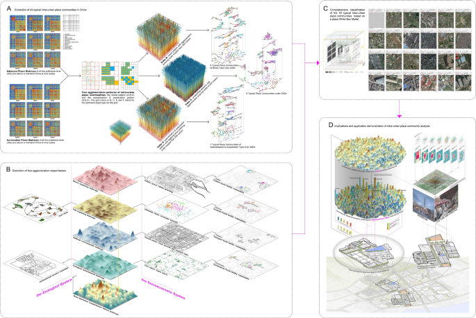
The earliest Chicago school of sociologists proposed monocentric and polycentric models of urban spatial structure6, zoning cities by functional and socio-economic attributes. And the concept ‘occupancy of the earth’s surface’ was put forward by Geographer Allen K. Philbrick to construct a multi-scale spatial unit system formed by the artificial built environment occupying the earth1. Later, relevant researches mainly transferred to the field of economics with a higher priority on the study concerning microscopic mechanism of agglomeration phenomenon. Marshall first discussed the phenomenon of industrial agglomeration on the topic7, and then Arrow and Romer further elaborated and developed it into the Marshall-Arrow-Romer (MAR) theory of spillover effects8,9 which emphasized the knowledge spillover within the industrial cluster. Jacobs attached much importance to the role of urban environment on knowledge spillover and innovation incentives10, which was called the Jacobs spillover effect, emphasized more on knowledge spillover from inter-industry partnerships. Duranton systematically summarized three mechanisms of micro agglomeration—sharing, matching and learning11. Following the concept of “industrial cluster” being first explicitly raised by Porter12, extensive researches on industrial clusters were conducted by using a large number of quantitative measures, such as the Herfindahl index13,14, the locational Gini coefficient15,16 and the Hoover localization coefficient17,18 to quantify industrial clusters within a sector; and other quantitative papers measured industrial clusters among different sectors by co-agglomeration or co-location indices19,20,21,22.To sum up, the attention on the spatial agglomeration phenomenon is mainly paid to industrial clusters in the economic field and statistical aggregated data is mostly used at the national scale or inter-city scale, which has two obvious shortcomings. First, oblivious of the agglomeration phenomena caused by factors other than the economy, such as the concentration of administration and public services that are not entirely governed by market laws, are based on political, environmental and historical ties23. Second, agglomeration phenomenon at the finer spatial scale within cities24,25 has not been given enough attention owing to the lack of fine geospatial data.As is known to us all, the dense concentration of socio-economic factors and activities, one of the essential characteristics of cities, shapes the urban spatial landscape where different types of places are mixed with each other and distributed unevenly in clusters11. Similar to the concepts of ‘cluster’ and ‘community’ in ecology, the ‘place cluster’ concept is defined as a group of places belonging to the same type that gather together within urban built-up areas, and ‘place community’ as a group of places belonging to different types. Since different types of places are always highly mixed in urban space, the study on place communities is of more practical significance. In addition, it’s also vital to study the micro mechanism and scale characteristics of intra-urban place communities for the development of spatial economic theories, micro-scale site selection of enterprises, and especially urban planning and design practice, in which the proper spatial unit is a core issue to construct a more efficient and sustainable urban spatial structure. Place communities may be the ultimate proper spatial units that urban planning pioneers including Howard26, Doxiades27 and Hall28 have been seeking in succession.This study, inspired from the above weaknesses of the current researches, endeavors to address the following three core questions: (1) How can typical intra-urban place communities be extracted quantitatively? (2) In which route do places inter-relate logically among place communities? (3) What are the practical enlightenments of intra-urban place community research for urban study and planning practice?To address these three core questions, (1) a quantitative data-driven approach is designed to extract 23 typical intra-urban place communities in China (Graph A in Fig. 1). (2) Then Four types of agglomeration forces are deducted (Graph B in Fig. 1), and the 23 typical place communities are classified into the four agglomeration force groups with the aid of a place White Box model (Graph C in Fig. 1). (3) Finally, a comprehensive demonstration displaying the application process of co-location/adjacent place matrices in auxiliary decision of the implanted place types is carried out with the example of the revitalization project of Taoxichuan Area in the city of Jingdezhen, China (Graph D in Fig. 1).Figure 1The flow chart showing the key steps of the research.Based on our perception of daily life phenomena, there are two spatial patterns of “specialization and cooperation” and “mixed” (Graph A in Fig. 1). This so-called “specialization and cooperation” pattern refers to the place communities in which the same types of places form a place cluster (specialization), and different place clusters locate adjacent to each other (cooperation). For example, similar manufacturing enterprises are distributed in the same industrial park forming a manufacture cluster at a small scale, and a snack cluster composed of many snack shops close to this manufacture cluster at a larger scale. The so-called “mixed” pattern refers to those place communities that are highly mixed within all scales. For instance, cold drink shops and restaurants usually cluster closely together at any scale.It is of great significance for extracting urban spatial units in urban planning and design practice to distinguish these two patterns. Thus we creatively propose a grid adjacent network analysis method on the basis of grid co-location probability concept in the evolutionary economic geography29,30,31,32,33,34. This concept can be commonly understood as the probability of two place types locating on two adjacent grids. Therefore, the simultaneous analysis of grid co-location probability and grid adjacent probability can distinguish the ‘specialization and cooperation’ from ‘mixed’ patterns among intra-urban place communities. As the grid scale becomes rougher, a pair of place types enters the ‘agglomeration mode’ at a certain scale when both the co-location and adjacent probability of these two place types are considerably high (above the top quartile), and exits from the ‘agglomeration mode’ when either of the co-location and adjacent probability is below the top quartile. Prior to the agglomeration mode, if the pair’s co-location probability is significantly high with the exclusion of its adjacent probability, the agglomeration pattern of this point pair is defined as the ‘specialization & cooperation’ pattern; otherwise, it is defined as the ‘mixed’ pattern. In this paper, the pairs that have entered the agglomeration mode twice or more are excluded since they are in an unstable agglomeration state.As the minimum grid in this study is at 200-m scale, it is impossible to distinguish the mixed pattern from the specialization and cooperation pattern when a place pair enters the agglomeration mode at 200 m. Therefore, we will discuss this situation separately which calls for the following-up studies concerning finer scales than 200 m.Three agglomeration cubes are constructed to vividly demonstrate the entering and exiting scales for each place pair (Graph A in Fig. 1). With the aid of these three agglomeration cubes, the significant agglomeration place pairs can be discovered and their agglomeration entering scales can be determined. To further exact typical place communities, the co-location (Cube B and C) or adjacent (Cube A) probability for each place pair at the agglomeration entering scale is normalized and recorded as the edge weight, and we take each place type as a node to construct a significant agglomeration place network for each of the three cubes. Then the total 23 typical place communities are further extracted by using the modularity algorithm in Gephi 9.2 software (Fig. 2).Figure 2Typical place communities (A01–A07, B01–B08, C01–C08) extracted from the significant agglomeration place network (A09, B10, C10) based on the modularity algorithm in Gephi 9.2 software (Graph A08, B09 and C09 show the modular groups with unique colors) for Cube A, B and C in this figure.Four types of agglomeration driven forcesFor the 23 typical place communities extracted from the three agglomeration cubes above, what factors lead to the spatial concentration among different place types? It is far from enough to answer this question only from the economic perspective of Jacobs externality. Since the city is an open dissipative system with both self-organization evolution process and hetero-organization process, within which the law of market economy is merely a rule in the self-organization process. In addition, the distribution of intra-urban places is also affected by environmental, political, cultural and other factors. To sort out the complex factors on the intra-urban place communities, we borrow some inspiration from the ecological niche theory which can well explain the agglomeration force of biological communities in the natural world.The ecological niche theory describes the phenomenon that different species occupy specific habitats and activity areas on the earth through fierce competition for environmental resources and the interaction of complex predation and symbiosis between species35,36,37. Judging from the definition, it is clear to see that there are three core concepts of ecological niche: the first one is the spatial habitat area of species (also generally known as spatial ecological niche, Graph 02 in Fig. 3), the second one refers to the resource constraint set (a high-dimensional space composed of adaptive fitness functions to various environmental resources, Graph 09 in Fig. 3), and the third one is the food chain (predation marks as the most essential interrelationship between species, and there exists Lindeman’s 10% law during the process of energy flow through the food chain, forming the biomass pyramid38, Graph 08 in Fig. 3).Figure 3Illustration of key agglomeration driven forces for intra-urban place communities. 01 and 02 express the phenomenon of different types of biological or place species occupying different areas of the earth’s surface. 03 illustrates the three-dimensional landscape of the overall attraction function of a location for a species. 04–07 show the four components of the overall attraction function. 08–09 demonstrate the main causes of ecological community agglomeration in ecological niche theory—food chains and species’ competition for various natural resources. 10 exhibits the theory of quantified relationships in the study of the intrinsic structure of communities—Lindeman’s 10% law of the process of energy flow in the energy-flowing pyramid of food chains. 11–14 exemplify the main causes of the agglomeration of place communities—hetero-organized behavior, self-organized behavior, artificial environment and natural environment. 14–18 elaborates the four types of place communities that correspond to the four main causes—political factor dominated, economic factor dominated, transportation factor dominated and environmental factor dominated. 19 explores a possible approach to the study of the quantitative relationships of the intrinsic structure of the place communities—the pyramid model of negentropic flows in the industrial chains.In light of the ecological niche theory, we proceed to elaborate the agglomeration dynamism within various typical place communities. Here we introduce the concept of overall attraction of a location on the earth’s surface for an ecological/place species (Graph 03 in Fig. 3), which is the sum of the environmental factors and inter-relationships between species that affect the spatial distribution of species. The spatial implication for both ecological and place communities is that a location enjoys high overall attraction for multiple species, which leads to the gathering of multiple species at this location. The overall attraction of a location can be categorized into two components: the environmental component and the inter-specific component. In ecosystems, the environmental component is mainly comprised of abiotic environmental resources such as temperature, soil, and air, and the inter-specific component is mainly linked through the food chain, since predation is the most important relationship among species. Whereas it is more complex for socio-economic place systems with two divergences. First, in addition to purely surface natural attributes, the environmental component also contains the influence of the artificial built environment, which is often referred to as the first nature and the second nature in the discipline of economic geography39. The accessibility determined by the structure of the road network directly affects land rent. Just as the fertility of the soil largely determines the total biomass of the ecological community, so the land rent in the socio-economic place system l
https://www.nature.com/articles/s41598-021-03917-1