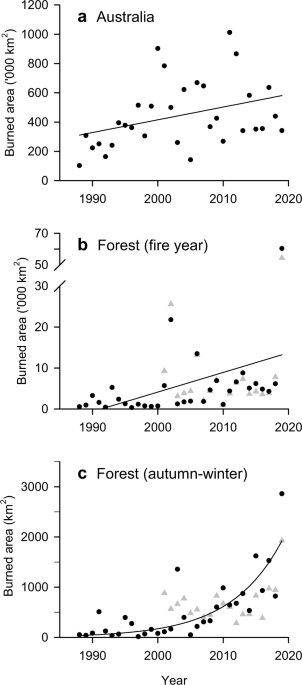
Multi-decadal increase of forest burned area in Australia is linked to climate change Fire activity in Australia is strongly affected by high inter-annual climate variability and extremes. Through changes in the climate, anthropogenic climate change has the potential to alter fire dynamics. Here we compile satellite (19 and 32 years) and ground-based (90 years) burned area datasets, climate and weather observations, and simulated fuel loads for Australian forests. Burned area in Australia’s forests shows a linear positive annual trend but an exponential increase during autumn and winter. The mean number of years since the last fire has decreased consecutively in each of the past four decades, while the frequency of forest megafire years (>1 Mha burned) has markedly increased since 2000. The increase in forest burned area is consistent with increasingly more dangerous fire weather conditions, increased risk factors associated with pyroconvection, including fire-generated thunderstorms, and increased ignitions from dry lightning, all associated to varying degrees with anthropogenic climate change. The extraordinary forest fires in Australia in 2019 and 20201 have brought further interest in detecting changes in fire activity, the possible role of anthropogenic climate change and their likely future trends both in Australia and globally2,3,4,5,6.Terrestrial ecosystems in Australia are among the most fire prone in the world, with fire regimes varying widely7,8. Fire activity is dominated by savanna and rangeland fires in the northern and western parts of the continent characterized by fire return intervals of less than 5 years7,9. Forests in the east and south have fire return times of decades to more than a century, with subtropical and tropical forests in the northeast burning rarely or not at all9. Fire, including cultural burns by indigenous people, has shaped the function and structure of most Australian ecosystems for millennia10,11.Against this background of fire activity, Australia’s mean temperature has increased by 1.4 °C since 1910 with a rapid increase in extreme heat events, while rainfall has declined in the southern and eastern regions of the continent, particularly during the cool half of the year12,13,14. These changes can affect the four components that must simultaneously come together for fire to occur: biomass production, its availability to burn (fuel loads), fire weather, and ignition7, making Australian forests vulnerable and sensitive to changes in fire activity.Previous studies showed increased fire danger due to changes in weather conditions over past decades in Australia5,15,16, climate change fingerprinting to individual fire events and trends17,18,19, and predicted increases in fire danger under future climate change due to increasing atmospheric concentrations of greenhouse gases2,20,21. Although these studies indicate more dangerous weather conditions for wildfires in a warmer world, studies also suggest that trends due to climate change might not be clearly detectable until later in the coming decades owing to the high natural variability and extremes of the Australian climate4,22,23,24.Fuel loads and trends, as effected by climate, human activity and time since the last disturbance, also play a role in determining fire risk25,26. This link is a central motivation for using prescribed burning to reduce fuel availability27, which in Australia is managed through changes in the frequency of prescribed burns28. Although there is some debate on their value to reduce fire risk29, particularly during extreme fire weather conditions2,30, fuel loads and their distribution and structure are key determinants of fire spread, intensity and severity7.Here we analyze trends of the burned area in forest ecosystems in Australia, which are dominated by temperate forests extending over the southern and eastern regions of the continent. We use a high-resolution (1.1 km x 1.1 km) burned area satellite record available based on NOAA-AVHRR (32 years), the NASA-MODIS burned area at 500 m resolution (19 years), and the fire histories from State and Territory government agencies (90 years). In addition, we analyze trends of nine wildfire risk factors and indices that relate to characteristics of fuel loads, fire weather, extreme fire behaviour, and ignition, which together with the burned area enable us to infer the causal influence of climate change on fire activity.At a continental scale, total annual burned area (fire year defined as July to June to include the Austral summer of December to February) using the NOAA-AVHRR dataset (‘Methods’: Burned area data), significantly increased over the past 32 years albeit with large interannual variability (Fig. 1a; Linear fit, p value = 0.04, Supplementary Table 1). The high variability is in part driven by large-scale modes of atmospheric and oceanic variability such as El Niño Southern Oscillation (ENSO) and the Southern Annual Mode31,32 that influence fire weather conditions16,22. Nine out of the 11 fire years, each with more than 500,000 km2 (>50 Mha) burned, occurred since 2000.Fig. 1: Burned area (km2) for each fire year (July to June) from 1988 to 2019.a Whole of continental Australia including Tasmania, linear fit; (b) Australian forests, linear fit; and (c) Australian forests for the Austral autumn/winter seasons (March to August), exponential fit (regressions in Supplementary Table 1). Data: AVHRR-Landgate (1988–2019, dots) and MODIS (2002–2019, triangles). Regressions are calculated using AVHRR-Landgate, and MODIS is shown for comparison.Forest ecosystems also show increased burned area over time (Fig. 1b, linear fit, p value = 0.02, Supplementary Table 1; Fig. 2). The increasing trend is statistically significant with and without the 2019 fire year, indicating a robust increasing trend even before the extraordinary large burned area of that year (Supplementary Table 1). Forests in Australia experienced an annual average increase of 350% in burned area between the first (1988-2001) and second (2002-2018) half of the record, and an increase of 800% when including 2019. The 2019 fire year burned about three times (60,345 km2) the area of any previous year in the 32-year AVHRR-Landgate record (Fig. 3, Supplementary Fig. 1, ‘Methods’: Burned area). The burned area of the 2019 fire year was estimated at 71,772 km2 based on State and Territory agencies (NIAFED) and 54,852 km2 based on NASA-MODIS, with an average for the three products of 62,323 ± 8,631. Ten out of eleven fire years with at least 5000 km2 (>0.5 Mha) burned have occurred since 2001. These trends are broadly consistent across the three burned area products (Supplementary Fig. 1).Fig. 2: Monthly burned forest area for fire years (July to June).Data: AVHRR-Landgate (1988–2019).Fig. 3: Wildfire burned area by states and territory in forest ecosystems for the 1930 to 2019 fire years.New South Wales and Australian Capital Territory (dark blue), Victoria (red), Queensland (light blue), South Australia (black), Western Australia (violet) and Tasmania (green). Data for 1930–2018 stacked bars are State and Territory agencies fire histories, supplemented with MODIS for Queensland in 2016–2018. Data for 2019 fire year are National Indicative Aggregated Fire Extent Dataset (NIAFED) by States and Territories (stacked bar), AVRHRR-Landgate (filled triangle), and MODIS (filled circle). See ‘Methods’: Burned area data.We find a positive exponential trend of burned area in forest ecosystems during the cool season months of the Austral autumn and winter (March to August), with a mean growth rate of 14% yr-1 (Fig. 1c; exponential fit, p value = 0.001; 9% increase without the 2019 fire season; Supplementary Table 1). These results indicate an extension of the fire season into the cooler months of the year, with more than a five-fold increase in the annual mean burned area in winter and three-fold increase in autumn between the first and second half of the studied period. However, spring and summer contributed about 10 times more to the increase in burned area than autumn and winter (Fig. 2; Supplementary Figs. 2 and 3). All seasonal linear trends were highly significant (p value < 0.001), and with p value = 0.07 for the summer season. The seasonal fractions of burned area for the 32-year period are 66% in summer, 24% in spring, 7% in autumn and 3% in winter.Along the latitudinal increasing temperature gradient from South to North (Tasmania, Victoria, New South Wales, and Queensland), we find that the largest relative growth of burned area between the early (1988–2002) and later (2003-2019) periods of the record occurred in the southern coolest parts of the forest distribution (Tasmania) and the northern warmest parts of the forest distribution (Queensland), with Queensland showing the largest absolute difference of the two.The AVHRR-Landgate data predominantly detects wildfires and misses low-intensity fires, including most prescribed (planned) burning33, suggesting the trends presented here are very unlikely to be affected by changes in prescribed burning ('Methods': Burned area data). This result is further corroborated by the lack of trends in the annual area of prescribed burning (see section below Fire risk factors and fuel load).Fire histories compiled from State and Territory agencies ('Methods': Burned area data), suggest that the extent of burned area for the 2019 fire year was also unprecedented since the 1930s when most agencies began to collect annual records (Fig. 3). Out of four forest megafire years (defined as the top 10 percentile years with most burned area) that have occurred since 1930, each with over 10,000 km2 (1 Mha) of burned area (1930, 2002, 2006, 2019), three occurred since 2000. Historical records show that no other forest megafire years occurred during the 1900s but that a large fire year occurred in Victoria in 185134. Further disaggregation into States and Territories, and wildfires and prescribed burning is shown in Supplementary Fig. 4.The increasing trend in annual burned area, and the exceptional 2019 fire year, become all the more significant against a concurrent diminishing of forest extent available to burn due to land clearing for pasture and agriculture35, and increasing bushfire firefighting capacity in Australia36,37.Years since the last fireWe further investigate trends in increasing burned area with an analysis of the number of years since the last wildfire (YSLF). The longer time series of the fire history records from State and Territory agencies enable us to construct a gridded database of wildfires at 250 m resolution to analyze decadal changes in the number of YSLF for all pixels that have burned at least once ('Methods': Years since the last fire). The analysis shows that 48.8% of all forest area has burned at least once since the 1930s. The burned fraction of the total area for each of the forest classes consistent with the Australian National Forest Inventory ('Methods': Forest extent and types) varied widely: eucalypt low-forest 61.1%, eucalypt tall-forest 60.6%, eucalypt medium-forest 58.2%, coastal non-eucalypt 54.3%, and rainforest 11.1%. Thus, YSLF estimates presented here do not represent a fire frequency for specific region or forest type, but they are correlated, as they have been estimated by a combination of observations and expert knowledge elsewhere9.For context, some of the dominant vegetation types such as tall eucalypt forests have typical fire intervals of 20 to 100 years with extreme cases with more than 100 years9. Lower stature eucalypt forests have typical fire intervals between 5 and 20 years with extreme cases with a range between 20 and 100 years9. Tropical forests have fire return intervals above 100 years9.The YSLF declined over the past four decades with decadal means (±SD) (all forests that had burned at least once since 1930s) of 70.6 ± 1.1 years, 68.1 ± 1.0 years, 53.2 ± 7.8 years, and 39.8 ± 8.1 years for the decades of 1980s, 1990s, 2000s, and 2010s, respectively (Fig. 4; continental figures in Supplementary Fig. 5). YSLF values for the last four decades of the record are the most robust due to the large amount of data from which they are estimated (cumulative), and therefore are the focus of this analysis. Fig. 4 reveals areas with rapidly declining YSLF, with some regions in Victoria with YSLF below 20 years. At the State and Territory level, the decade of 2010s shows a range from 46 ± 21 in Queensland to 33 ± 4 in Victoria, with a minimum of 18 ± 4 years for the Australian Capital Territory whose forests were largely burned in 2003 and again in 2020 (Supplementary Table 2).Fig. 4: Number of years since the last wildfire (decadal mean) for forested areas.Analysis based on forested areas that have burned at least once since fire records began in the 1930s for most states. Spatial resolution is 250-metres. Data: State and Territory fire histories.Fire risk factors and links to climate changeThere are four components that drive fire activity: weather that influences fire spread, ignition sources, biomass accumulation (fuel loads), and dryness of fuel loads (fuel availability)2,7. In the next three sections we address each of these four factors and show trends of various indices and quantities which we link back to changes in fire risk over the past 40 years.We use a daily dataset of McArthur Forest Fire Danger Index (FFDI) values gridded throughout Australia15. This index is specifically developed to indicate weather conditions across the 'Danger'
https://www.nature.com/articles/s41467-021-27225-4
Multi-decadal increase of forest burned area in Australia is linked to climate change