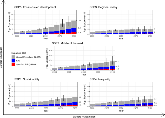
Assessing population exposure to coastal flooding due to sea level rise The exposure of populations to sea-level rise (SLR) is a leading indicator assessing the impact of future climate change on coastal regions. SLR exposes coastal populations to a spectrum of impacts with broad spatial and temporal heterogeneity, but exposure assessments often narrowly define the spatial zone of flooding. Here we show how choice of zone results in differential exposure estimates across space and time. Further, we apply a spatio-temporal flood-modeling approach that integrates across these spatial zones to assess the annual probability of population exposure. We apply our model to the coastal United States to demonstrate a more robust assessment of population exposure to flooding from SLR in any given year. Our results suggest that more explicit decisions regarding spatial zone (and associated temporal implication) will improve adaptation planning and policies by indicating the relative chance and magnitude of coastal populations to be affected by future SLR. Sea-level rise (SLR) accompanying climate change will cause significant and costly impacts in the 21st century and beyond. Avoiding adverse consequences depends on our ability to undertake accurate assessments of the populations already affected, and those projected to be affected, to inform adaptation planning and the ability to adapt to such consequences1. Research has long sought to identify the impact of SLR on coastal areas2,3,4, with an increasing focus on estimating exposed populations and associated assets2,5,6. The human population is concentrated in the low-elevation coastal zone (LECZ; those <10 m above sea level) with more than 600 million people living in the LECZ globally7, and despite the increasing rate of SLR related flooding8, the global LECZ population is growing: more than 1 billion are forecast to live in the coastal zone by 20605.Scientific assessments estimating the populations affected by SLR date back at least four decades and are relatively common in the scientific literature. Intense interest in this topic is due to the magnitude and severity of SLR flooding as a climate impact, the clear potential implications for human migration9, the growing size of global coastal populations5, the relative simplicity of producing estimates3, and the increasing availability of both geophysical and population data products from local to global scales7. However, the magnitude of the population estimated to be affected ranges widely across studies. At the global level, the population estimated to be affected by SLR ranges from a low of 88 million10 to a high of 1.4 billion5. These wide-ranging estimates can be attributed to several considerations, including: (1) differing spatial zones of 'at-risk' that influence estimates of how many people will be affected by SLR, and (2) differing temporal horizons implied by any given spatial zone that affect estimates of when increased flooding and associated impacts due to SLR will occur. A third major consideration is the deployment of different datasets and methods to calculate exposure. Examining the contribution of different datasets and methods to wide-ranging estimates of SLR exposure is beyond the scope of this paper. For simplicity, we use the term 'spatial zone' throughout the paper to describe inland areas relative to the coastline. However, we recognize that in some cases for these zones, we are discussing areas that are representative of 'spatio-temporal zones' such as the 100-year flood plain, which while explicitly spatial, is dependent upon the temporal notion of a 1% chance of flooding in any given year.The modeling choices around spatial zone of population affected by SLR imply a temporal horizon for when impacts will unfold. These temporal horizons can be forecast from as short as 100 years11 to as long as 2000 years or longer6,12, pushing SLR impacts deep into the future. However, permanent inundation is not the most immediate impact of SLR. Regular daily to annual tidal flooding (e.g., nuisance flooding) events are likely to be the most disruptive to life in the near term8, and related impacts are already occurring in many parts of the world (e.g. coastal erosion13, coastal flooding14, and saltwater intrusion15). Yet each individual spatial zone overlooks the spatio-temporal continuity of SLR impacts on a coastal landscape. Such spatio-temporal differences in assessments of populations affected highlight some of the limitations of singular, or limited, spatial zones for adaptation planning.In a systematic review of research assessing populations affected by SLR, we identify 46 studies that meet our search criteria (See Supplementary Material). Each of these studies assessed populations affected by SLR using varied spatial zones of exposure. The spatial zone of SLR exposure assessed in these studies ranged from mean sea level (narrowest zone) to the LECZ (broadest zone). Twenty studies (43%) used more than one spatial zone, nine (20%) used more than two, and four (9%) used three or more. The most common three, from narrowest to broadest spatial zone, assessed populations affected as follows: (i) complete inundation or submergence under the future high-tide line (n = 20), (ii) extreme water levels such as storm surge via the 100-year floodplain (n = 17), and (iii) the LECZ (n = 11) (Supplementary Table 1). Of the seven spatial zones used in at least three studies, 61% (n = 28) of the studies used at least one of the three common zones, 13% used two, and only one study16 used all three. These are the same three common spatial zones identified in previous studies9,17. McMichael et al.17 referred to these three zones as Specified Levels of SLR, Coastal Floodplains, and the LECZ and we adopt those labels here.Recurrent tidal flooding or flooding on an annual basis and flooding for a specified return level (Coastal Floodplains) is the exposure category where we expect impacts that are most immediate and severe18,19,20. Perigean spring tide events cause regularly recurring water levels well above high tide, and in many coastal areas these cause significant flooding, sometimes referred to as nuisance flooding or recurrent tidal flooding8, particularly when these tidal events are enhanced by significant onshore winds from tropical cyclones or storms.Eventually, recurrent tidal flooding gives way to permanent inundation and submergence of coastal areas under future high tides. The future high-tide line (Specified Levels of SLR) is the narrowest delineation of exposure to SLR (i.e. transition from land to ocean), and commonly implies societal impacts that include permanent loss of settled areas, migration, and community relocation9. These areas are threatened by inundation and will ultimately be the most adversely affected locations, but societal losses will occur prior to permanent inundation and are dependent on adaptive measures that may be undertaken in advance. It is important to note that this strict delineation eschews other hazards associated with SLR.Areas located beyond the Coastal Floodplains and within the upper bounds of the LECZ broaden populations exposed to coastal flooding and especially its extended impacts while carrying much less of a chance of flooding, but still include associated SLR hazards (such as soil salinization)5,21. Simply residing within the LECZ does not guarantee direct exposure to a SLR hazard such as a storm surge, but it does carry increased probability of exposure to the side effects of an extreme event through extended impacts on, for example, livelihood opportunities. For example, some populations residing within the 100-year floodplain may experience recurrent tidal flooding, permanent inundation, storm surges, and saltwater intrusion in coming decades,8,22,23,24 while those beyond it are less likely to experience such effects. Broader zones such as the LECZ render any coastal area as 'exposed' to SLR in nearly any time period, which makes it difficult to determine exactly who is exposed to SLR-related effects and when they are exposed. For our study, however, we do not assess these extended impacts, rather we specifically highlight the estimated populations that could be indirectly affected by flooding events triggering other impacts in the LECZ.There are three main advantages to examining SLR exposure assessments across the three most common spatial zones. First, by accounting for the probability of flooding at locations between the LECZ to the mean higher high water (MHHW) mark into a single analytical framework, we better describe how possible differential impacts vary across space. Different populations within the coastal zone have differential exposure to flooding, allowing for more nuanced discussions of what it means to be 'exposed' to SLR.Second, each individual approach implies varying temporal windows. Specified levels of SLR assume SLR exposure only at the moment when areas are permanently submerged. Conversely, the LECZ represents the most inclusive estimate of exposure to SLR hazards potentially over millennia with high emissions and future sea level under high emissions will far exceed the LECZ if it is kept fixed relative to present sea level12. Between these two extremes lie Coastal Floodplains with a gradient of exposure to multiple hazards associated with the slow, continual rise in water levels.Third, analyzing the most common approaches provides a framework for examining the entire range of population exposures to SLR impacts. Each spatial zone when applied often assumes homogeneity of impacts by identifying populations exposed based on their presence within each designated zone: people are either inside or outside the LECZ; inside or outside the 100-year floodplain; above or below specified levels of SLR. This equality of exposure within each chosen spatial zone ignores the variability within the actual zone itself. Those projected to live under the future high-tide line are exposed to virtually all SLR-associated hazards: soil salinization, recurrent tidal flooding, storm surge, livelihood impacts, shoreline erosion, etc. In contrast, those who live at higher elevations within coastal communities might only be exposed to storm surge and indirect livelihood impacts. Allowing for variation of exposure, as we have done here, permits an examination of multiple scenarios that might unfold along the spectrum of flood exposure in the coastal zone.While we still use the above approaches and recognize their value in what population exposure assessments indicates related to the extended hazards beyond flooding, taken individually, no one approach to characterizing spatial zone is likely to accurately represent the heterogeneity of hazards associated with SLR nor quantify the spatial zone or timing of exposure to flooding. One approach to this problem is the EAE, a unifying spatio-temporal metric that characterizes exposure across all spatial zones using a finite time period (one year) for planning decisions. Unlike other approaches, the EAE indicates the population exposed to annual flooding by summing the range of annual exposure probabilities over space under any given Representative Concentration Pathway (RCP), an exposure profile that changes over time.Furthermore, most previous assessments focus on assessing the populations exposed specifically to flooding disregard the annual probability of population exposure to flooding above the high-tide line spanning from the relatively frequent nuisance events (such as a spring/king tide) to 100-year floodplains and beyond. While some studies of SLR impacts have examined expected annual damages (e.g.,11,25,26), analysis of the expected annual exposure (EAE) of populations to flooding is relatively new27,28,29. EAE allows for integrating across the most common spatial zones into a single, continuous, model of populations annually exposed to flooding due to SLR from the high-tide line to the 10,000-year floodplain. Few assessments of EAE, however, apply projected estimates of future populations, which could serve as indicators of future impacts. Thus, we combine the EAE model with sub-county population projections in the United States to characterize SLR hazards between 2000 and 2100 under three of the IPCC's Representative Concentration Pathways (RCP 2.6, 4.5, and 8.5) and all five Shared Socioeconomic Pathways.In this work, based on our own review and previous work9,17, we analyze population exposure for the three most common spatial zones from the high-tide line to the LECZ. We show how this approach allows for better inter-model comparisons between estimates and, crucially, clarifies their differential exposure estimates related to SLR. Furthermore, we examine the EAE for the same areas and suggest that it benefits adaptation planning by showing the annual increase in populations likely to be directly affected by annual flooding events representing the leading edge of SLR impacts. Although adaptation will occur in the future, we do not account for adaptation measures in this analysis, instead interpreting potential future population exposure as an indicator of potential impacts. We emphasize that the EAE is not a replacement for the others, which have their own merits, but that it instead standardizes the broad coastal zone range into an all-inclusive spatial region centered on annual flood exposure; a metric that we suggest indicates the rate of change in populations exposed to annual flooding in a manner more easily interpreted for local level adaptation planning.We find that in the year 2000, the expected number of people in the United States exposed to an annual flood event is just over 600 K people, 150 K people lived below the high-tide line, and 2.4 M people lived in the 100-year flood plain (Fig. 1). The combination of coastal population growth and SLR between 2000 and 2020 has already increased the EAE of the US coastal population by 60% (610 K to 980 K), increased the US coastal population living below the high-tide line by 60% (150 K to 240 K), and increased the US coastal population living in the 100-year floodplain by 45% (2.4 M to 3.5 M), despite just a 25% growth in the entire coastal population over the same period.Fig. 1: Projections of sea level rise flooding exposure under Representative Concentration Pathway 4.5 and all five Shared Socioeconomic Pathways (SSPs) for 2000 to 2100.Uncertainty reflects the 95th percentile prediction interval. Each spatial zone is not mutually exclusive, but cumulative. 9.2 million people in the Infrequent Flooding Effects zone under SSP1 is inclusive of those in the two preceding zones.As the century progresses, SLR places the US coastal population at increasing chance of exposure to flooding (Fig. 1 and Table 1). Under the SSP2 and RCP 4.5 emission scenarios between 2020 and 2100, we project the EAE to increase 325% to 4.1 M people (2.3–6.4 M); we project the US coastal population below the high-tide line to increase more than 435% to 1.2 million people (0.3–5.1 M); and we project the US coastal population living in the 100-year flood plain to increase 160% to 9.0 million people (3.4 –22.3 M). Lower estimates use SSP3 and the 5th percentile projection in RCP 4.5 while upper estimates use SSP5 and the 95th percentile projection from RCP 4.5 unless otherwise noted. At the same time, we project the population in the 406 coastal counties to increase by just over 40% (133–190 M). Importantly, this indicates that exposure to coastal flood hazards
https://www.nature.com/articles/s41467-021-27260-1
Assessing population exposure to coastal flooding due to sea level rise